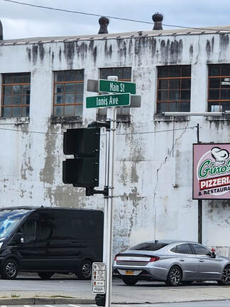
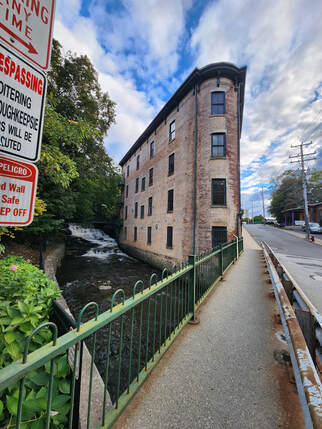
(Use This Technique to Interest Students in History & Geography) Fiddlers Bridge, Sleight-Plass, 9 Partners, and Crum Elbow are some of the roads where I live. They have strange names. The places do, too: Shekomeko, Spackenkill, Amenia, and Wassaic are just a few of them. People who’ve lived in Dutchess County their whole lives don’t seem to think about the labels, but, having recently moved here, I wonder who attached such unusual monikers and why were they so christened. Once I find out what I can about those really weird names, I’ll tell people, because, for me, learning has always gone hand-in-glove with teaching. Teachable moments come up at all sorts of random times and I plan to sneak my findings into conversations. You can use the history of location names in a classroom, as well! My Investigation I wanted to know who the 9 Partners were and what the words "shekomeko" and "spackenkill" mean. But first, I compiled a list of unusual road names and places around Dutchess County. My list includes such notables as Dog Tail Corners, Cricket Hill, and Bulls Head (roads), as well as Poughquag (a hamlet) and Milan (MY – lan, a town). 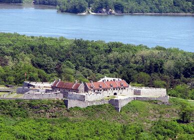 Fort Ticonderoga--French & Indian War; Revolutionary War. Fort Ticonderoga--French & Indian War; Revolutionary War. There has to be a history to those names. After all, New York is a very historic state, having 270 National Historic Landmarks, the most of any of the 50 states. Nearly half of those landmarks (129) are in Dutchess County! 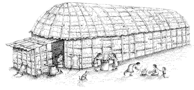 Knowing the history of this place can surely yield a greater understanding of the roads and geographic areas. (I remember learning about the Iroquois’ Longhouses in seventh grade.) But, since the last US History Class I took was more than forty years ago, I needed a refresher. Googling helped me write a brief synopsis of the history of Dutchess County within the larger state of New York. Before there was a Dutchess County 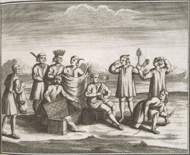 Iroquois trading with Westerners. Iroquois trading with Westerners. The first peoples to live in present-day New York are estimated to have arrived in 10,000 BC. Around AD 800, the Iroquois’ ancestors moved into the area from the Appalachians. The predecessors of the Algonquian peoples also lived in the region. By around 1100, the distinct Iroquoian-speaking and Algonquian-speaking cultures that would eventually be encountered by Europeans had developed. 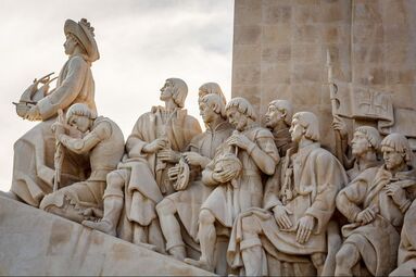 The Age of Exploration (15th – 17th centuries) brought Europeans to the Americas seeking religious and political freedom, as well as economic opportunity. (Some people also came as indentured servants and slaves.) The European empires of Spain, Portugal, Britain, France, Russia, the Netherlands, Denmark, and Sweden all laid claim to lands and natural resources in the New World. 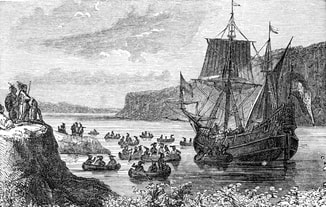 Henry Hudson's ship on the river bearing his name. Henry Hudson's ship on the river bearing his name. The land that includes present-day New York was known as New Netherland from 1614-1674. The Dutch colony was a major port for trade in the North Atlantic. When the British conquered New Netherland, the colony and major city were renamed New York, in honor of the Duke of York. A second port city, “Beverwijck”, was renamed Albany, for the same Duke, who was also the Duke of Albany. That Duke (James II) later became King of England, Ireland, and Scotland (1685-1688). 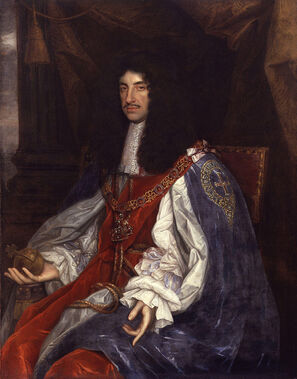 The British considered the King (at that time Charles II, James’ brother) to be the only source of legal title. Therefore, previous land purchases made from the Indians were invalidated. Once New York was divided into counties (in 1683), large tracts of land in Dutchess County were divided among men of money and influence. Land “patents” were granted to them by the British crown. Among those lands were the Rombout Patent, The Nine Partners' Patent (Great/Lower), The Rhinebeck Patent, The Beekman Patent, Little/Upper Nine Partners' Patent, and The Oblong Patent. The "proprietors" of those patents were joint owners who then subdivided, surveyed, and conveyed smaller land allotments to others. Over time, the county was divided into precincts and then towns. Use This in Your Classroom If you live in the Hudson Valley Region, certainly use this post and any adjoining links, in your classroom. If you live elsewhere, here is an activity you can use with your students to guide them in researching and writing about special places near their home. Here are my rankings of the 17 BEST PLACE NAMES in DUTCHESS COUNTY: 17-Dutchess County is named for a Duchess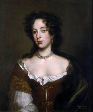 The county itself has an interesting name because of its spelling. Dutchess County was named in the honor of Mary Beatrice d’Este, The Duchess of York, who never visited the area. In that, the county is like other locations in the New World (Virginia, named for the Virgin Queen Elizabeth; Maryland, named for Queen Maria; and Georgia, named for King George II, none of whom came to America). The spelling of Dutchess County is derived from the seventeenth-century spelling of "duchess". Within the county, there are other noteworthy names. 16-Pleasant Valley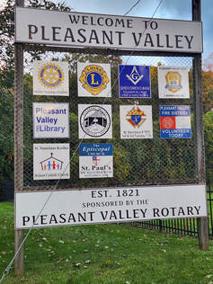 In 1821, some of the town of Clinton was carved off to form the town of Pleasant Valley. The land area, which was part of the Great Nine Partners Patent of 1697, had been a hamlet called Charlotte (according to http://pleasantvalley-ny.gov/). A couple of real estate related websites claim that the name “Pleasant Valley” was chosen to deflect notoriety from the “infamous Henry Dodson Murder Case, in which the town councilman was found brutally slain, with rumors that he had opposed the Great Nine Partners Patent of 1697 on grounds of its dubious legality”. There were further claims that the legality of the Great Nine Partners Patent “was considered highly questionable” and that “many believed that the Nine Partners were holding unfair rule over the region through the use of extortion and threats of violence”. I was unable to find any corroborating information about the reason for the town’s name change, Henry Dodson, or any consensus that the Great Nine Partners operated outside of the law. But that’s a great story and I hope its true!! 15-Nine Partners Road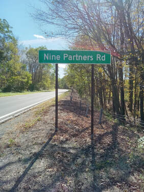 The Great Nine Partners were well connected men. They were Hendrick ten Eyck, Lt. Colonel Henry Filkin, Major Augustin Graham, James Emott, William Creed, John Evertson, David Johnstone, Jarvis Marshall, and Colonel Caleb Heathcote. Together, they owned a majority of property in Dutchess County. I have not located any credible/historical website that indicates that they were involved in any shady dealings in Dutchess County's infant stages. But if they were, HBO could serialize it, like Boardwalk Empire. 14-Wappingers Falls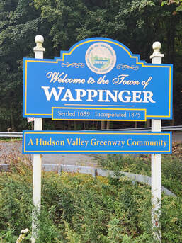 What is now the town of Wappinger was part of the Rombout Patent, the first of fourteen land patents. It included 85,000 acres of land, the majority of southern Dutchess County. Wappingers Falls was named for the cascade in Wappinger Creek. The Wappinger were an Algonquian-speaking confederacy of indigenous people whose territory in the 17th century extended along the eastern bank of the Hudson River. Wappinger means "easterner" in most Algonquian languages. 13-Innis AvenueInnis Avenue (County Route 115) runs into Worrall Avenue, south of route 44, and Salt Point Turnpike, north of Pehl Road. It is named for George Innis, who ran the Innis Dye Works Company in the mid- to late-1800s. Innis was also a three-time Mayor of Poughkeepsie. The Innis Dye Works Factory, where materials that would be made into dyes were pulverized and stored, is located at 82 North Water Street in Poughkeepsie. Since the 1800s, the building has had other uses. It was converted to condominiums in 2008.
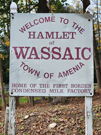
12-Sleight-Plass RoadSleight-Plass Road was named for two major farms. Sleight Farm was located at the road’s junction with Overlook Road. Hickory Ridge Farm, owned by the Plass Family, was located farther north along the road, at the border of Pleasant Valley. 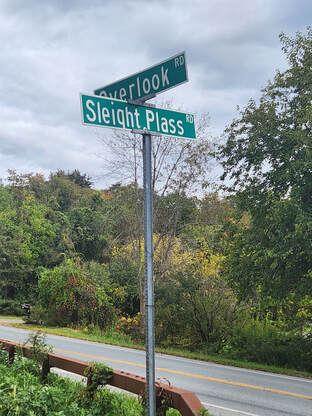 The original Sleight Farm dates back to 1765, when Abraham Sleight purchased the land. Sleight Farm continued to be family-owned and run by the next five generations of Sleights. In the 1980’s, family members found they could no longer maintain the farm, and the land was sold to developers. Today, the Sleight Farm single-family home community includes the (restored) Sleight Farm House, as well as 150 acres of open-space conservation land. Hickory Ridge Farm was in continuous operation since the late 18th century, but was sold in 2015. It’s now owned by the Haight Family and is called Hudson Valley Cold Pressed Oils (https://hudsonvalleycoldpressedoils.com/). The farm is located at 235 Sleight-Plass Road. 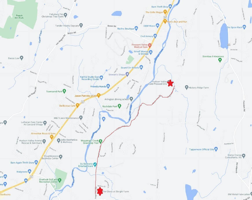 The names of Innis and Sleight-Plass Roads have historical significance. Places are commonly given the last names of important people. That's just not as much fun as being named for the (possibly) evil Nine Partners. And for those who follow notorious acts or are crime junkies, another compelling name is the one that occupies the eleventh position. 11-Fiddlers Bridge Road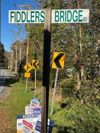 A bridge once stood on a road connecting Pleasant Plains to Schultzville. Though the bridge has been removed, the road retains its name to commemorate a murder that occurred in 1808. At that time, a fiddler, who played at local dances, was murdered while walking home. His body was abandoned on the bridge and, as a result, the bridge, and later just the road, was renamed for that event. 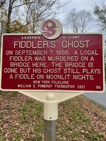 The road had been used to bring produce to the Rhinecliff docks for transport to New York City; it was formerly called Farm to Market Road. But the story of the fiddler (and the possible reasons for his murder) were passed down in local lore. People claimed that, at midnight, on moonlit nights, fiddle playing could still be heard. In fact, as reported in the Poughkeepsie Daily Eagle, a group taking a hay ride on the 100th anniversary claimed to hear fiddling at the former bridge site. And even in 1992, some locals performed a reenactment of the fateful event and, indeed, there was fiddle music (performed by a local teenager costumed in a white sheet). 10-Crum Elbow Road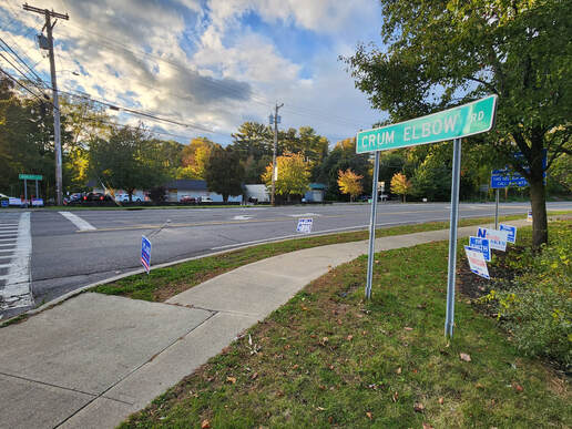 Crum Elbow Road (County Route 41) connects State Route 9G with Quaker Lane. Route 9G runs along Crum Elbow Creek. The Dutch settlers in the New World used the words Kromme Elleboog, meaning a bent or crooked elbow, to name the creek. In the seventeenth and eighteenth century, Kromme was eventually rendered to Crum while Elleboog was translated to Elbow. 9-Bulls Head Road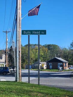 The name Bulls Head is not original. Arlington was once named Bull’s Head. The Bull’s Head Inn in Cobleskill dates to the 1700s. The zip code of Bulls Head, Staten Island is 10314. In Dutchess County, the road (County Route 19) runs from Center Road in Clinton to State Route 82 in Stanford. Dutchess County is surely farm country and there are cattle here, but Bulls Head Road is not shaped like a bull’s head. If it were, Bulls Head Road could be depicted like this: 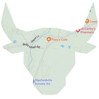 8-Milan (MY-lan)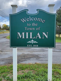 Milan is not an original name either. What is now the city of Syracuse was known as "Milan" from 1809 and 1812. A settlement 40 miles south of Syracuse was also originally called "Milan" in 1790, before its incorporation as the town of Locke. And, of course, there is Milan, Italy, but that is ME-lan. It’s not unusual for places in the New World to be given European city names, as in Poland, Madrid (pronounced MAD-rid), Amsterdam, and Phoenicia, all in New York. 7-Amenia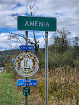 The name, Amenia, is derived from the Latin word amoena, which means “beautiful”. This name was coined by Thomas Young in 1762 when the precinct was formed. Young was a physician, poet, a writer of political pamphlets, and a Latin scholar, who also gave the State of Vermont its name (for the Green (“vert”) Mountains (“mont”) within the state). He also participated in the Boston Tea Party. 6-WassaicThe name Wassaic comes from the Native American word Washaic, meaning "land of difficult access" or "narrow valley". The Europeans accessed it by following the Housatonic River valley up from Long Island Sound and through the mountains along the Ten Mile River.
5-Poughquag Sylvan Lake is a hamlet in the Town of Beekman. It is named after the lake within its border, which was formed during the Ice Age. Indigenous peoples called that lake "Poughquag", meaning "round body of water". Today, Poughquag is another hamlet three-and-a-half miles east of the former Poughquag (current Sylvan) Lake. 4-Spackenkill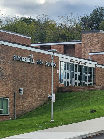 Spackenkill Road (No road sign!) is CR 113 Spackenkill Road (No road sign!) is CR 113 In the early 1900s the Spackenkill was referred to as Specken zyn kil. That was a Dutch interpretation of indigenous words for "speaking waters”, a name given to a noisy stream that ran through Spackenkill Road. Today, the headwaters of the Spackenkill Creek are within the Casperkill watershed. The Casperkill (also called Jan Casper's Kill) is shown on maps as Casper Creek. It flows 11.6 miles from Peach Hill Park to the Hudson River. The creek lies entirely within the British royal grant of 1685 known as the Rombout Patent. 3-Cricket Hill RoadThere is a similarly named hill in Chicago. It is an artificial hill, built in 1948, that is 45 feet high. It is used for sledding and hosts an annual kite festival. The less interesting history associated with the hill’s moniker is that, before the hill’s construction, the site had been used as a cricket field. Another fun, if morbid, possibility, published in the Chicago Tribune, is that three elephants were killed in a circus train collision in the 1800s. Although two were buried elsewhere, Cricket, the name of the third elephant, was buried at Buena Park. Cricket Hill, within the park, is that elephant's grave. 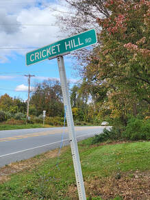 Cricket Hill Road in Dover connects New York State Route 22 with Old Route 22. The actual hill is 538 feet high, nearly twelve times the size of the hill in Chicago. Ergo, the other two circus elephants are probably buried in Dover. (In case you’re wondering, all of the elephants performed under the stage name Cricket.*) 2-shekomeko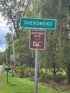 Shekomeko is located between Pine Plains and Amenia in Dutchess County. It was a village of the Mohican people (an Algonquin tribe). They lived by a stream which Anglo-Americans later named Shekomeko Creek, after their village. Shekomeko comes from the language the Mohicans spoke. It means "place of eels", suggesting that, at one time, the creek may have had a sizeable American Eel population. Today it has Wild Brown and Brook Trout populations. 1-Dog Tail Corners Road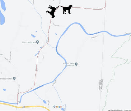 Here is a picture of the Road (County Route 22), which connects New York State Route 55 with Bulls Bridge Road in Connecticut. You can practically see two dog’s tails forming a corner. Documenting locations near where you live can help you understand the area better. It certainly did for me. Photograph places near you and learn how they came to be a part of your home. Maybe they’ve experienced some changes. There are probably aspects about them that remain unchanged. Explore how and why your geography exists as it does today! *Narrative license ; o )
0 Comments
Leave a Reply. |
AuthorGertrude Katz has spent over 30 years teaching K-12 public school students all major subjects. She has taught biology and education at the college level. The majority of her career has been spent instructing biology at the secondary level. Categories
All
|
 RSS Feed